The following is an account of my mountain bike tour which mostly followed the Colorado Trail bike route. The ride took place from 9/15/25-9/22/25. Enjoy the trail logs, photos, and route data!
Check out my full route on Caltopo here to follow along with the logs: https://caltopo.com/m/2FD3CQT
Monday 9/15

After picking up my parking pass, parking, and packing my bike up, I barely had enough time to ride down the parking structure and down to the bus stop. I did prioritize getting a burrito on the way. As I arrived at the stop, the bus was just pulling out. Luckily, I was able to flag down the driver to pick me up.
About 5 hours later, I got dropped off with my bike and all my gear at the Federal Center bus station in west Denver. Somehow I completely forgot to pack my food for this first leg of the trip, so I made two brief stops to resupply along my route. They were very nerve wracking, being in a big city without a lock. In both instances I parked my bike in the grocery store vestibule and voile strapped the rear wheel to the frame as a minor theft deterrent.
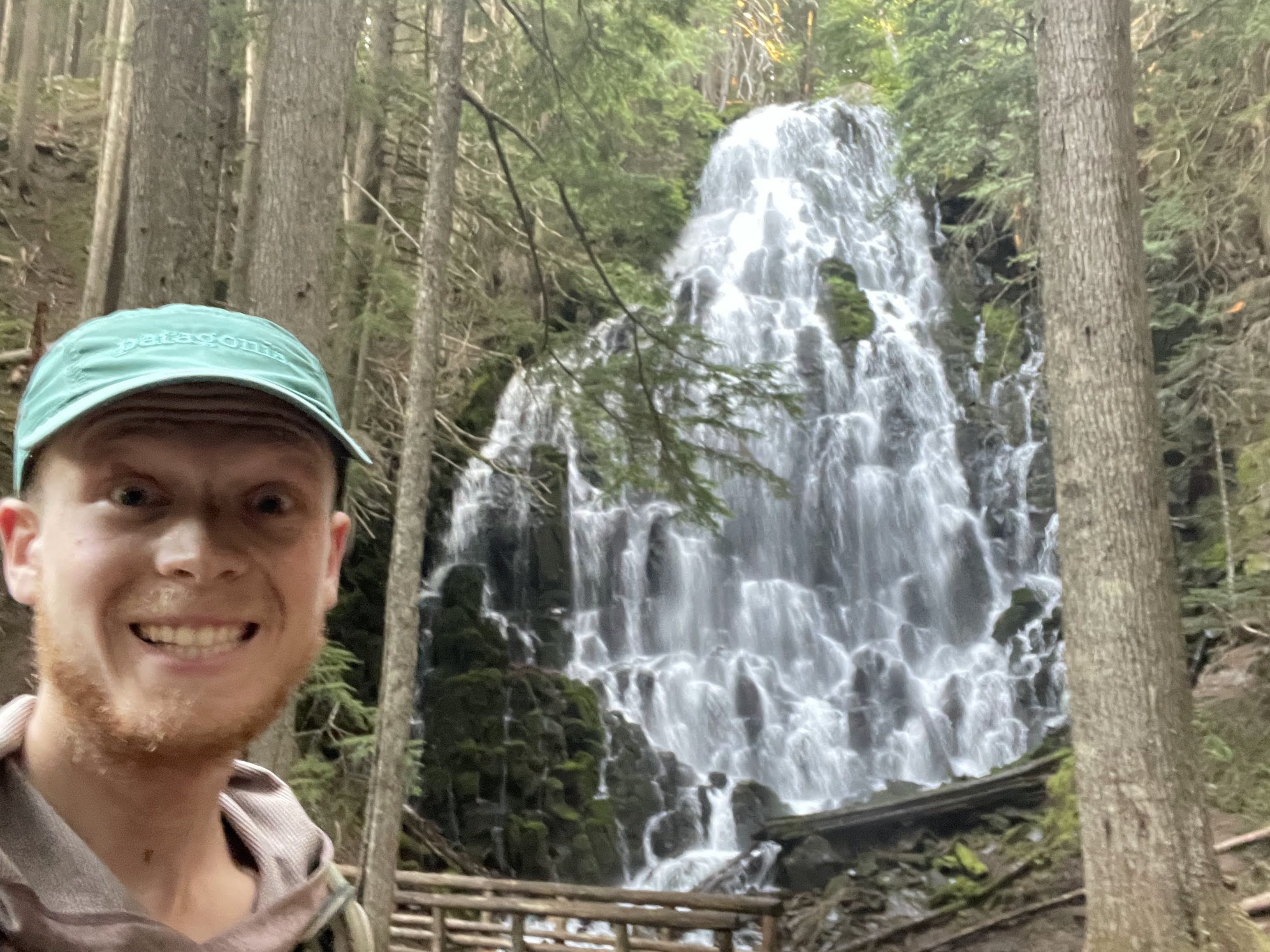
I finally got to the trail at about 5:20, which was a flat, well graded gravel road for about 7 miles, before a short singletrack climb and descent. I am camping at Bear Creek, which is a good water source with a nice flat tentsite nearby. I’m enjoying a sourdough baguette with havarti for an appetizer, an entree of cold soaked indo-mie, and chocolate for dessert. I’m looking forward to a full day of riding tomorrow and really getting underway!
 |
| Beginning the singletrack |
Tuesday 9/16

After filling up I had ten more miles of sweet singletrack until I hit CR126, a paved road which I took for about ten miles south. At Cheesman Trailhead, I hung a right on FR211, which I stayed on for the next 24ish miles, into the small town of Tarryall.
The going was steep on this road, and there was a surprising amount of traffic for it being dirt. I kind of bonked on the third climb or so. Luckily there was a great place to stretch out and refuel at Goose Creek. I even went for a dip in the water, which was very refreshing.
I did make a big bonehead move… after changing from shorts to bibs, I left my favorite riding shorts, of probably 5 years and thousand of miles, on a stump by the creek! By the time I realized it there was no way I was going to turn around and get them. Not with the way my legs were feeling.
After reaching the pavement, which was quite a relief, I rolled slowly to Spruce Campground. On the way there, I hesitantly split off for about a 1 mile detour to find the oldest geocache in Colorado, and the oldest one I’ve logged to date!
Once I arrived at the camp, I stopped to unload in the pit toilet and filled up a bit of water. The water there was a bit questionable. There was plenty flowing, but definitely some livestock upstream. I took what I needed, as I didn’t really have another option.
Finally, 10 miles later, I made it to my camp for the night, at Tarryall Reservoir. I had to ride a bit past camp, also along Tarryall Creek, just a bit upstream, to load up.
The water in the reservoir is disgusting. I am camping at a free site right on the water. Tomorrow I’m making a bit of route change to grab some more food. I underestimated how strenuous, and therefore calorie intensive, the trail has been so far. I’m excited to get a good night’s rest. I need it.
 |
| Cruisin' on FR211 |
 |
| Camp at Tarryall Reservoir |
Wednesday 9/17

Waking up and getting on the bike was a very cold experience, especially with my back to the sun once I did begin riding. I spent most of the first 15 miles of the day riding no handed with my hands flat on my lower back, palms out, to absorb as much solar radiation as absolutely possible, and to keep my cold fingers out of the wind. I decided to take an extension to the Lost Creek wilderness detour through the town of Jefferson, the home of a produce stand and breakfast burrito manufacturer.
Unfortunately, my information was outdated. Neither of them were open on Wednesdays, which completely eliminated the whole point of my detour extension.
After I dried out my gear in the warm sun, I hopped back on my bike and tied in with the CT at Jefferson Lake Road, after following CR35 for a few miles. From there it was a long, gradual climb to Georgia Pass (11850’), that was luckily mostly rideable. The northwest facing descent off the back was still covered in lots of snow from the previous night. It was a very wet, muddy descent. By the time I got to the bottom I was absolutely frigid.
When I checked my satellite weather and it showed near certain rain in the next two hours, I made the gametime decision to roll the forest road into Breckenridge. I arrived at the Bunk House Lodge a bit after 2 and took the bus into town to replace my shorts and get some snacks for tomorrow. I also had the best sandwich of my life at Soupz On. I even got another one for dinner, but could only eat half of it due to its immense size.
I hopped on the free local bus back to the Lodge, which is actually part of a very extensive transit service all around the Denver metro area and up through the ski areas along I-70. It was nice to have a more mellow ride today after a bit of a sufferfest yesterday. Excited to get some sleep.
 |
| A snowy descent off Georgia Pass |
 |
| The best sandwich I've ever had, plus liquid calories |
 |
| Bunk House Lodge, Breckenridge |
Thursday 9/18

The climb up Gold Hill was cold enough that I wore my puffy up the first 1000’ of vert. After breaking treeline, the going was chunky and steep, making going slow for the remainder of the 3700’ climb. I still managed to make the summit by 11 o'clock, which was a great start to the day.
The descent off the backside was epic. Lots of smooth, flowy singletrack, with some super steep chunk mixed in. The descent was long enough to demand a quick break to finish my leftover sandwich, rehydrate, and give my hands a quick break.
While enjoying my sandwich I discovered a potential alternate route that would shave off about 2000’ of climbing, something that would substantially lighten my load for the day. It involved following a bike path to a series of county and forest roads. After following the bike path for a few miles, and up a nontrivial climb (I did have an amazing tailwind), I arrived at the end of path/start of road, only to meet a security man and a no trespassing sign. Little did I know, the route that appeared to be most likely public (I knew there was a chance of it being private, which softened the blow) was actually a series of roads through the largest Molybdenum mine on earth. As I was later told by the Climax Mine Head of Security, if I had ridden my bike through there I wouldv'e been crushed by an ore hauler with 13 foot tires, and the driver would've had no idea.
Anyways, I took a leak, confirmed the man’s claims about the private roads on a map, and turned back on the bike path to Copper Mtn. There was an alternative route along Colorado 91, but it was not of much interest to me for various reasons.
After arriving back at Copper I was able to follow the blazes through town and onto the trail quite clearly… until I missed a turn and blindly assumed I was on route. By the time I realized it I was invested a few hundred feet of vertical. I scoped out a potential route using a mix of various maps and satellite imagery, and was able to slip through the upper west side of Copper Mtn to the CDT/CT. It was a nice, loamy trail that obviously did not see a lot of traffic.
After tying in to the singletrack, the climb was very similar to that of earlier in the day, but it wasn’t quite as steep or chunky, which I found to be very nice.
The descent off the backside of Kokomo Pass into Camp Hale was possibly the best I’ve ever experienced. I cut off the trail so soon as I had the opportunity to hop on an extremely well graded gravel road climb, with a great tailwind.
I hopped on US24 when I reached it just a few mile later for a couple more miles of easy climbing. At the summit of Tennessee Pass I took a nice rest in the sun and read interpretive signage about the 10th Mountain Division, which has an amazing history and legacy, in both the colorado ski scene and the National Ski Patrol.
The ride on the road from Tennessee Pass to Leadville was super chill. My body ached from the days riding, but the rolling 10 miles of pavement came quickly and easily.
As soon as I arrived I headed straight to Inn the Clouds, my accommodation for the night. I went and got the “Pregnant Burrito” from the local Mexican restaurant, which contains two chile rellenos, then grabbed some snacks for tomorrow and an ice cream from the convenience store. Back at the hostel I got to talk shop with a couple of CDT hikers.
Tomorrow is going to be a much more mellow day. I might try to up my mileage if the weather is nice. There is a fair amount of precipitation coming in on the forecast that I'd like to be ahead of.
 |
| Pass #1 of the day |
 |
| Pass #2 of the day |
 |
| Leadville, the highest city in the USA |
Friday 9/19

The day started with a cold road ride, the new normal, before starting a gradual climb along Halfmoon Creek. Once back on the CT the trail was absolutely superb. The climb was well graded enough that I could ride most of it, and the singletrack descent through aspen tunnels was unreal.
I made it around Twin Lakes and then veered off course. A more gradual climb on a forest road was supposed to tie in to the CT, but a recent fire made the trail unrecognizable. I continued on the forest road with hopes of reconvening, but it didn’t pan out. The section of CT I unintentionally missed was not very long or scenic.
Back on US24, I rolled downhill until CR371 was available for me to hop on, on the opposite side of the Arkansas river. CR371 was perhaps the smoothest dirt road I've ever seen in my life, and for basically the entire 10 miles or so. I cruised down the river for about an hour before arriving in Buena Vista, my minimum destination for the day. Luckily, it wasn’t even 1 o'clock yet!
I stopped into the grocery store for a 1 day resupply, then rolled across the street to Sorelle, a deli. I got a big sandwich which I ate on the front porch. After digesting a bit and getting extremely hydrated, I hopped back on my bike to get in some bonus mileage. There was a 16 mile leg from Buena Vista to Mt Princeton Hot Springs that I originally had intended to camp along, but it was looking like it was in my wheelhouse to complete today.
The road, headed west, out of Buena Vista was going directly into one of the most brutal headwinds I’ve ever experienced. I almost turned around and went back into town. Luckily, a few miles later, when I turned back onto the CT, it subsided.
After a steep climb, the trail was fast and flowy once again. I made great time getting to Mt Princeton, where I grabbed an Electrolit and an ice cream sandwich. I enjoyed both on their lush lawn.
Back on the bike, I made quick time getting up to the trailhead once again. This climb was the most brutal of the day, ascending over 800’ in just a mile. I probably rode about 40 yard of it, pushing the entire rest of the way. But just like the previous segment, that climb paid off big time.
I enjoyed a long, gradual descent followed by fast rolling terrain all the way to my new destination, Browns Creek. Here I stay at an expansive campsite with an awesome water source. I enjoyed a dinner of rice and beans, along with a bit of muesli for dessert. I gave my bike a little attention too: adjusted the headset, revived the dropper, and replaced the front brake pads. Tomorrow there is an afternoon storm in the forecast. I will ride down to US50 and hope to climb the 2500’ to Monarch Crest by noon. There I will recheck the forecast, do my last resupply until Cathedral Ranch, and hopefully enjoy a burrito. If the storm looks severe, or if it doesn’t and I’m feeling lazy, there is a backcountry cabin about 10 miles from the crest. Otherwise I’ll shoot for the base of Sargent’s Mesa. I am halfway done with the trail at this point, almost exactly in terms of both distance and elevation. With the upcoming weather I might be making some detours to avoid the highest areas. I should arrive in Durango between Tuesday and Thursday next week.
 |
| Inn the Clouds, Leadville |
 |
| A snapshot of some all-time singletrack |
 |
| Poaching some grass at Mt Princeton |
Saturday 9/20

I reached US50 by about 9:30, where the main event of the day began: a 2500’ climb up to Monarch Pass. The climb went pretty smoothly and the drivers were generally very courteous. Riding with high speed traffic does tend to put me in a bit of a frantic state, so I definitely rode a bit harder than ideal for the duration of the climb.
When I got to the top I was smoked. And I missed the breakfast window at the summit restaurant by half an hour. Luckily, they still had a soyrizo burrito for me to order and enjoy. I grabbed a few snacks at the mini mart, filled my bottles , checked the weather and potential camping options, and hopped back on the bike.
The next section of trail was a very popular mountain bike shuttle route. I saw more vehicles than I could count hauling bikes on my way up the pass. With the popularity setting my expectations high, I was quite underwhelmed by the descent. Compared to the fast, flowy, aspen lined descents that I had enjoyed so much during the last few days of riding, the descent seemed chunky, slow, and blown out.
The main downhill ended at Marshall Pass, the site of the cabin. The cabin was locked and the weather looked good, so I set my next destination as Tank Seven Creek. The trails south of Marshall Pass were quite loose and chunky. They were dirtbike trails. It made the going slow, but I managed to make it to the creek by 4.
I filled up my water and assessed my situation. It was still a little early to set up camp, but the water sources were few and far between for the range of trail I could make it to by nightfall. Luckily, a northbound CT hiker happened to hike by and shared some helpful information.
First was that the climb up to Sargent’s Mesa was not nearly as bad as I had heard. Second was that there was a nice lake just half a mile off trail ten miles south, the perfect distance for me to complete in the allotted daylight. I had a quick snack and hopped back on the bike.
As soon as I started pedaling, the rain began to fall. I had felt a few drops earlier, but nothing significant. As I continued to climb, the rain intensified for a little while before tapering off. It drizzled off and on for the remainder of the climb, until I reached the base of the short climb to the Baldy Lake trail. Then it really started coming down.
I hammered hard, knowing the lake trail was close. As soon I reached the trail I dropped in to the 250’ descent, which was a loose mess of greasy rocks and roots, and one of the more fun technical descents that I enjoyed, despite the circumstances.
Finally I reached the lake, where a southbound CDT hiker and his dog sat waiting. I pulled up into a stand of trees, and the rain started to relax. After receiving approval from hiker and dog, I chose a tentsite right next door and set up.
I enjoyed a tasty dinner, identical to last night’s, before promptly hopping in bed. Tomorrow I have 50 miles and 4400’ of very to take care of to reach Cathedral Ranch, my next resupply. The weather looks clear for the day before more fills in Monday into a heavy day of precipitation Tuesday. We will see where I am and how I can avoid the worst of it.
 |
| Up on the Monarch Crest |
 |
| Getting back to dirt |
Sunday 9/21

Last night was a wet one. It rained on and off until about midnight. I opened up the flys on my bivvy only for the rain to resume about 5 in the morning. When I woke up an hour and a half later, there was forecasted to be a 100% chance of rain until 10. I did not want to get out of the bed. After waiting for a little while I finally opened up the door and saw a couple patches of blue sky, which was enough to get me moving. I took a while to pack everything up. When your gear is wet and it’s cold out it’s very easy for your fingers to go numbn while packing.
Eventually I had my bike loaded up and rolled out from my campsite a bit after 8 o'clock. The climb out of the lake was not so bad. The next dozen miles of singletrack to get to the road were grueling though. I was very happy I did not attempt them last night.
It took me about 2.5 hours to get down that trail before I hit CO114. From there the going was easy all the way to Cathedral Ranch. I had a long paved downhill, followed by a long gravel downhill. The gravel flattened out for a bit before rising ever so gradually all the way up to Los Pinos Pass at 10500’. There was a fun descent afterwards down to Cathedral Ranch, which was probably my favorite resupply of the whole trail.
As soon as I arrived I grabbed a Coke, Fritos, an ice cream sandwich, and a couple Babybells for lunch. Meanwhile, my wet gear from last night was hung to dry in the sun and wind. I enjoyed my meal, plugged in my phone to do some navigation and planning, and grabbed some more food for the road. The owner of the ranch and her dogs kept me company. Finally, after an hour spent refueling and recuperating, I hopped back on the bike for the 2500’ up to Slumgullion Pass.
With a whole bunch of calories in my stomach and fresh legs, I absolutely destroyed the climb. I was at the top before I even knew what happened, stopping only once to chat with a motorcyclist. At this point I made a turn right onto CO149 where the official Colorado Trail bike detour goes left. The next section of trail was extremely high elevation. With the incoming weather, I’m going to take a lower route via Cinnamon Pass, which tops out about 1000’ below the peak of the CT, and spends much less time at that elevation.
The paved descent into Lake City was absolutely ripping. I’d ridden this descent once before, and it was even more fun than I remembered. I arrived at the River Forks RV park, a recommendation I found on FarOut, at 5:50. I hastily checked the closing times of the local grocery stores, and was able to get down to Country Market just 3 minutes before closing. When I returned, I was invited to help consume the remainder of the RV park potluck, an activity I gleefullty participated in. Finally, with a full stomach, I booked a bunk in their cabin, took a nice hot shower, and threw my clothes in the washing machine, all included in my stay.
Tomorrow I have the longest singular climb of my entire ride up and over Cinnamon Pass, at 25 miles and 4500’ of climbing. I am not very excited honestly. I am also trying to beat a somewhat heavy afternoon precipitation forecast. Once I reach Silverton, the rest of the ride will be all gravy, as the forecast improves and I roll my way downhill towards Durango.
 |
| Breaking a wet camp at Baldy Lake |
 |
| My rig on Los Pinos Pass Road, FR788 |
 | |
| Cathedral Ranch |
 |
| The view from Slumgullion Pass |
Monday 9/22

I stayed at a little bunkhouse at the River Forks RV Park in Lake City, CO with another cyclotourist. We both happened to be going over Cinnamon Pass the following morning, so we awoke to a 6 o’clock alarm. I checked the weather report again as soon as I woke up, and it appeared to be a bit more favorable than the night before. After getting loaded up and eating a bit, I was on my bike and rolling at 6:35.
The going was easy for the first 15 miles or so as I followed Cinnamon Pass Road, up until the fork with Cottonwood Creek Road. For the last 10 miles the grade steadily increased and the road became rougher. I pretty much walked all of the last 4 miles of road to the summit of Cinnamon Pass.
I had completely beaten the weather. When I arrived at the top it was cold and windy, which is to be expected at 12,640’. Otherwise, it was a pretty nice day. I threw on some warm clothes, had a 4wd operator snap a photo of me at the summit, and started flying down the 3,300’ into Silverton.
When I arrived in Silverton it was only 11:15. I was beginning to wonder whether or not I should’ve taken the high route. But the barista at the cafe I went to assured me that I would’ve been up there until dark at least.
I enjoyed my sandwich while pondering my options for the remainder of the day and evaluating the weather. Stay in Silverton? Ride road to Durango? Camp at Little Molas Lake? The options were overwhelming. The route I had planned was 68 miles with 7,900’ of climbing. If I opted to get back on trail, I would either need to wait at Little Molas Lake or push over the pass at Rolling Mountain (hereby referred to as Rolling Mountain Pass), at 12,450’, before the impending storm came through.
Eventually I decided I at least needed to start moving again. I made a quick stop on the way out of town for some extra rations.
I got on US550, which would take me up almost half of the climb to Rolling Mountain Pass. About halfway up the climb, I ran into a pair of Ecuadorian cyclists who were also riding the CT. They were rolling road back to Durango to get out of the weather, and I was very tempted to make the same choice. But after noticing how fresh my legs still felt, and reviewing the map one more time, I decided I would take my originally planned route of the Colorado Trail to Hermosa Creek Trail, and try to get to Durango by that night. I informed the Ecuadorians and stomped on the pedals.
Most of the trail from Little Molas Lake to Rolling Mountain Pass was easy going. There was a lot of smooth singletrack traversing, which I enjoyed immensely. As I distanced myself from treeline though, the going got much harder.
I kept on chugging and made the summit of the pass by 3:15, just as the weather started to turn. The descent off the back was steep and loose, and rain began to fall as I plummeted toward Cascade Creek. I took a break to fill my water, have a large snack, and more than anything, rest my hands. As I began the last substantial climb of the day, up to the saddle between Sliderock Ridge and Graysill Mountain, the storm came into full effect.
The rain and hail began to dump, and I found a good spot to hang out under a pair of dense conifers. I layered up and settled in, as I wasn’t planning on going anywhere until the precipitation and nearby lightning just about stopped.
Finally, after about 20 minutes, the rain dwindled so far as to tempt me to start rolling. Of course, once I made my move the storm made one too, and before I knew it I was hunting for another dense tree.
No more than 10 minutes later I was rolling again, this time for good. I popped over the summit at 5:15, into a broad meadow with a great line of trail slicing right through it.
I made great time getting down the last section of Colorado Trail that I would be riding. I passed my last potential campsite with good water, which I did not know at the time, and made the turn onto Hermosa Park Road. Little did I know, I was about to begin the most hellish section of my entire ride.
Hermosa Park Road was a steep, fast descent. I made the 10 mile descent to the Hermosa Creek Trail trailhead in under 40 minutes. At that point I turned onto the 20 mile long Hermosa Creek Trail. At the same pace, I’d reach the bottom by 8 o’clock, about the time of last light. Unfortunately the going was much slower.
The sky began to darken as I futilely continued to check my map. The trail seemed to drag on forever. It was in a recent burn zone, and the foliage was very overgrown. The short climbs were usually too steep to ride. Eventually I had to stop and get my lights out. I decided at that point that I would fill up water at the next source and camp at the campground near the end of the trail.
The last two water sources proved to be undrinkable. There were cow hoofprints and turds lining the streams for as far up as I wanted to follow them. Durango it is, I thought to myself.
By the time I reached the road it was 8:40, and I was overjoyed. The descent was smooth and fast, and I reached CR203 before I knew it. From there it was smooth sailing into Durango, with a just a bit of precipitation, and one of the strongest tailwinds I've ever experienced.
I rolled into town at 9:30 and headed to The Junction hostel. They were completely booked, so I went next door the Adobe Inn and snagged their only vacant room. I was relieved to be done riding for the night.
I completed my route in 7 days and 7 hours, with a grand total of 520.96mi and 54,334' of elevation gain. My complete route is available in the CalTopo map linked below. I did not follow the Colorado Trail to a tee by any means, but I enjoyed a great week of cycling and camping and exploring Colorful Colorado. Until next time...
 |
| The first objective for the day, Cinnamon Pass |
 |
| Climbing US550 up and out of Silverton |
 |
| Approaching Rolling Mountain Pass |
 |
| Atop the last climb, before the long descent into Durango |
 |
| That's a wrap, folks! |